Cotoni-Coast Dairies Land History
Cotoni-Coast Dairies in Santa Cruz County extends from the steep slopes of the Santa Cruz Mountains to marine terraces overlooking the Pacific Ocean. Approximately 5,800 acres, it encompasses ancient archaeological sites, riparian and wetland habitats, coastal prairie grasslands, and woodlands that include stands of coast redwood.
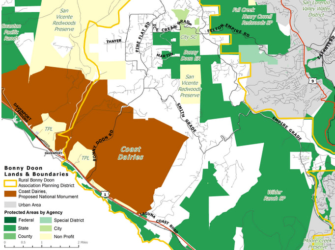
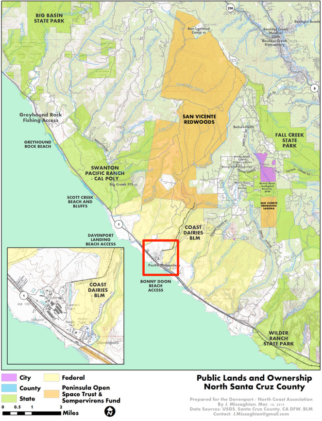
Click on maps to enlarge |
|
1901-1998: Private Ownership
The original inhabitants of the property now known as Coast Dairies were the Native Americans who came to be known as the Ohlones, most likely, according to sources, their Awaswas band. Despite many centuries of human habitation and use, the property still appears, though of course it is not, in its natural state. But in reality it has been strip-mined for limestone and shale, its forests clearcut, and its streams dammed and piped for farmers, ranchers and city dwellers, and its native flora overrun with invasive species.
In 1901 the 7,500 acres of land today known as Coast Dairies & Land, which stretches from the ocean at Laguna Beach north past the town of Davenport to Scott Creek and into the lower reaches of Bonny Doon, was purchased by a Swiss family, which owned and operated dairies on the property until the 1920s. It contains 6 watersheds, 3 levels of marine terraces covered by chaparral, coastal dunes and gorgeous beaches and coves. In its upper reaches, forests of oak, madrone, fir, pine and redwood thrive. On its lower slopes, land leased to farmers is used to grow pumpkins, artichokes, Brussels sprouts and other crops.
The open stretches of Coast Dairies provides important hunting and grazing grounds and migration routes for pumas and other wildlife, including some sensitive or rare species like the California red-legged frog, and its streams provide water for the City of Santa Cruz and habitat for endangered steelhead and coho salmon. Its beaches teem with seabirds and pinnipeds like seals and sea lions.
Diverse individuals and groups have worked for decades to protect the North Coast. In the late 1960s developers were promoting an ordinance that would have allowed parcels north of Santa Cruz to be divided into quarter-acre lots. Santa Cruz County Planning Commissioner and co-founder of Big Creek Lumber Company, Bud McCrary, approached the County Board of Supervisors with an emergency ordinance that prevented any subdivision smaller than 5 acres. The Supervisors passed the emergency ordinance, which stopped the developers.
In 1995 a Nevada development company acquired a stock option to purchase the Coast Dairies property, and proposed to divide the land into as many as 139 luxury residential lots and build a marina.
The development was fought by local environmental groups and individuals, and area conservation groups and foundations and the State government put together enough money to make an offer to the development company. Under the umbrella of the Save the Redwoods League, the purchase was finalized on Oct. 26, 1998 for a reported price of $40 million. The money came from the Packard Foundation, the California Coastal Conservancy, The Nature Conservancy, other locally funded Santa Cruz Land Trust donations and some other State funds.
For some more discussion of the North Coast history, see the Santa Cruz Public Library article at santacruzpl.org/history/articles/382/
1998-2006: The Land Preserved, the Management Process Begins
Save the Redwoods League passed ownership rights to TPL, the Trust for Public Land, whose responsibility it was to create a long-term property management plan which would be predicated on protection of the land from development or environmental degradation. Public access to the property’s beaches continued, but access to the uplands was deferred until a management plan was in place. A broad group of federal, state, and local interests, and the public, were invited to participate in the creation of the plan. The William and Flora Hewlett Foundation and the Coastal Conservancy provided funds to support drawing up the plan, which was required to comply with the California Environmental Quality Act and the National Environmental Policy Act.
As time passed it became clear that TPL intended to turn the landward acres of the property over to the federal Bureau of Land Management and the beaches to the California Department of Parks and Recreation. Before this could happen, however, it seemed that the yet-to-be-completed management plan would determine how BLM and CDP would be able to use the land. Strict deed restrictions were put in place to ensure that the land was well protected from adverse uses, like mining, commercial logging, or motorized recreation vehicles.
TPL formed a Citizens Advisory Group to provide input in the development of the management plan. Its first meeting was in September 1999. Groups participating on the task force were environmental organizations included the Rural Bonny Doon Association, the California Native Plant Society, the Surfrider Foundation, Friends of the North Coast, farmers, Big Creek Lumber and RMC Inc. (the Davenport cement plant owner at the time), and federal, state and local government agencies and schools.
The management and public use plan was to be developed by TPL with the task force’s input, and that of a Steering Committee consisting of Save The Redwoods League, the Land Trust of Santa Cruz County, the State Coastal Conservancy, the Santa Cruz County 3rd District Supervisor’s office (the late Mardi Wormhoudt, a champion of land conservation, was 3rd District supervisor at the time), BLM and CDP.
The first step was to assess the property’s resources, flora and fauna, and, existing leases and historical uses, and then identify areas that need to be protected or restored and those that could be used for recreational, agricultural and other activities. Then alternative management options were to be developed and analyzed and the final plan selected. It was unknown how long the process would take, but expectations at the time were no more than 2 or 3 years.
In 1999, responding to pressure from mountain bikers, surfers and other groups who felt left out of the advisory group, TPL decided to open it to anyone who wanted to participate. With this action it quickly became questionable whether the advisory group would have any meaningful influence. By opening it up to anyone, rather than limiting it to organizations with a clear constituency, the advisory group’s role became much more muddled. Still, TPL indicated that it hoped to have the management plan completed by August 2001.
Despite some funding hiccups, planning for the Coast Dairies and Land property finished the first stage: the Existing Conditions Report. It might have been called “here is what we’ve got to work with,” a simplistic phrase belying the enormously complex task of planning for the huge property. This work was carried out by a technical consulting firm called Environmental Science Associates (ESA). The result of this research on Coast Dairies was a ponderous document presented to the TPL on July 14, 2001 and later released to the public.
TPL presented its “Opportunities and Constraints Analysis” (OCA) in November 2001, and held a meeting for the Community Advisory Group (CAG) on December 1 to discuss and explain this important document. The OCA followed up on the “Existing Conditions Report” and represented the “what we can do with it” phase of the process. It was designed to delineate a planning framework for a property with diverse and complex management needs. Resource management and planning policies from State Parks and the Bureau of Land Management were incorporated, since the recommendations were to become the basis for the final plan, once various alternatives had been considered.
CAG members became concerned because language describing logging policies was inconsistent with the original Vision Statement drafted by the steering committee. CAG members were also concerned about provisions of the 1872 Mining Act which might have allowed new mining claims to be filed on portions of the property to be conveyed to the Bureau of Land Management. It was not clear whether County and Coastal Zone ordinances that prohibit certain land uses would have to be honored by federal law.
The long-running planning process moved to the next phase after the CAG convened in January 2002 to offer their input before the comment period closed on February 1. TPL consultants worked on drafting the management plan alternatives to be presented to the CAG by spring.
The Management Plan and associated documents stalled while several water issues were sorted out. The Coast Dairies planning team had expected to provide the next deliverable planning documents in May 2002, with its CAG meeting to follow in June. These documents now had to be modified to reflect the impact of reduced water availability. The revised version was to be issued in late August with a CAG meeting to follow in September.
The Santa Cruz County Board of Supervisors voted money to rehabilitate and improve 2 farmsteads on Coast Dairies property but only if the farmland remained in production for 20 years. State Parks balked at the conditions. They knew water supply problems were imminent, so they refused the money and never made the improvements.
The CAG met for the last time in July 2003 and attendees heard BLM staff deliver more bad news for farming on the North Coast. Legal staff advised BLM that it did not have legal authority to take over Coast Dairies agricultural leases and agricultural-worker housing leases, one of TPL’s stated goals from the beginning. The CAG was then disbanded.
In response to water concerns, in winter 2003 TPL told farmers on the Coast Dairies property that its entity which held title to the land, Coast Dairies & Land Company (CDLC), would not continue to seek creek diversion permits, would not seek water rights and would not design, fund, or construct any off-stream storage. This action was in response to scrutiny from regulatory agencies. After touring the property in July 2001 and examining the infrastructure that supplied water to various fields, state and federal officials warned CDLC of problems with water rights and the design of diversion structures as well as concerns about water levels needed to be maintained year-round for the health of steelhead and coho salmon in North Coast streams.
The CDLC told farmers that they would be offered reduced rent and encouraged to convert irrigated agricultural lands to dry farming, which offers little profit. It became clear that CDLC no longer intended to complete the required Environmental Impact Report for splitting the agricultural parcels off from the main portion of Coast Dairies property. This meant the plan’s environmental review would be carried out by State Parks and BLM. BLM officials in Sacramento indicated their willingness to accept the property with some restrictions. These were still being negotiated and would have to be approved by officials in Washington, D.C. This concerned local environmentalists, because the George W. Bush administration favored the interests of mining, logging and oil exploration over environmental protection.
In March 2004 Santa Cruz County Counsel notified TPL in writing that the transfer would require compliance with the Subdivision Map Act as well as require a Coastal Development Permit (CDP). Compliance might take many months once applications for the permits were submitted to the County.
State Parks was slated to acquire the lands west of Highway 1, including the coastal beaches. The bulk of the lands east of the highway were to go to BLM, with the remaining agricultural lands going to Agri-Culture, the educational branch of the Santa Cruz County Farm Bureau. TPL wanted to rethink their options and the land transfer was postponed.
2006-2014: Public Acquisition
In a deal heralded as the most significant addition of beaches to Northern California state parks in 31 years, the transfer of 5 miles of Santa Cruz North County beaches, 407 acres in all, from CDLC to California State Parks Dept. was finally completed. Transfer of the balance of the CDLC /TPL property to BLM was scheduled for later in 2006.
When the time came for TPL to divide and transfer the land to BLM it became clear that the goals and restrictions identified by the CAG and the Management Plan would not necessarily be applied to the property when it was transferred. TPL claimed the property transfer was exempt from requirements for a Coastal Development Permit. Letters from Santa Cruz County Counsel reinforced the position of the Coastal Commission staff but TPL instead continued to look for ways to exempt itself.
In February 2010 a letter from the Santa Cruz County Planning Department informed the public that the County would not require a CDP. However, State law required the County to ask the Executive Director of the Coastal Commission to determine whether a permit was required. The County was asked to request that determination and settle the question but the County declined, so in March, a Petition was filed in Santa Cruz Superior Court on behalf of Save Our Agricultural Land and several entities including the Rural Bonny Doon Association, requesting that the Court force the County to comply with Coastal Commission rules.
The suit dragged on, bouncing back and forth from Superior Court to the California Appellate Court. In March 2014 TPL agreed to apply for a Coastal Development Permit. Late in 2014 the suit was finally settled and in December Santa Cruz County registered the agricultural conservation easement SOAL and its associated plaintiffs fought for, guaranteeing that the agricultural parcels would remain as farms in perpetuity. It stated that there would be preferences for organic farming, that pesticides would not be used within 275 feet of the town of Davenport, that commercial logging would be prohibited, that there would be a ban on recreational motorized vehicle use, and that access to the upland (non-agricultural parcels) for recreational pursuits (hiking, etc.) would be maintained.
With legal issues out of the way TPL transferred the remaining 5,800 acres of Coast Dairies to BLM in April 2014. BLM announced that it would open limited public access within a year, but then backed off and said that instead it would offer periodic guided tours. In March 2015 the head of BLM’s Central Coast division said that he planned to open a 2-mile loop trail near the Laguna Beach parking lot sometime in 2015.
Meanwhile, in early 2014, the Sempervirens Fund with other conservation organization partners acquired from CEMEX corporation 8,500 acres stretching through San Vicente Canyon from near the closed Davenport cement plant north up to Empire Grade in Bonny Doon. The land had been used for limestone mining and timber operations. The new owners changed the name to San Vicente Redwoods and the Land Trust of Santa Cruz County was put in charge of developing a public access plan.
2014 to the present: Public Access and the National Monument Campaign
Soon after, Reed Holderman, at the time Sempervirens’ Executive Director, began pushing a plan to have Coast Dairies designated a national monument. Nevertheless, Sempervirens Fund’s Board of Directors voted not to try to have San Vicente Redwoods, which adjoins Coast Dairies, included in the monument. Holderman maintained that with a national monument designation, Coast Dairies would be better protected from adverse uses and would have access to more funds for facility development and stewardship.
Sempervirens and Holderman also pushed to change the name of Coast Dairies to Santa Cruz Redwoods National Monument, despite more than 100 years of history and the fact that there are very few redwoods on the property, none of them “old growth”. The new name seemed solely aimed at gathering support for the national monument campaign, which FONC fought because we knew that Coast Dairies was already strongly protected and that monument status would only serve to attract more human use, to the detriment of the property’s environment and biotic resources. FONC also strongly opposed the name change, and suggested that a name that honored the original human inhabitants, the Cotoni (pronounced cha-tone’-ee) tribelet of Ohlone Indians, and the Swiss dairy farmers, would be more appropriate. In concert with the Amah Mutsun Land Trust, which represents the remaining members of the Ohlone tribelets, FONC pushed for the name to be Cotoni-Coast Dairies National Monument. When President Obama signed the proclamation in January 2017 adding the property to the California Coastal National Monument, that is what he named it.
